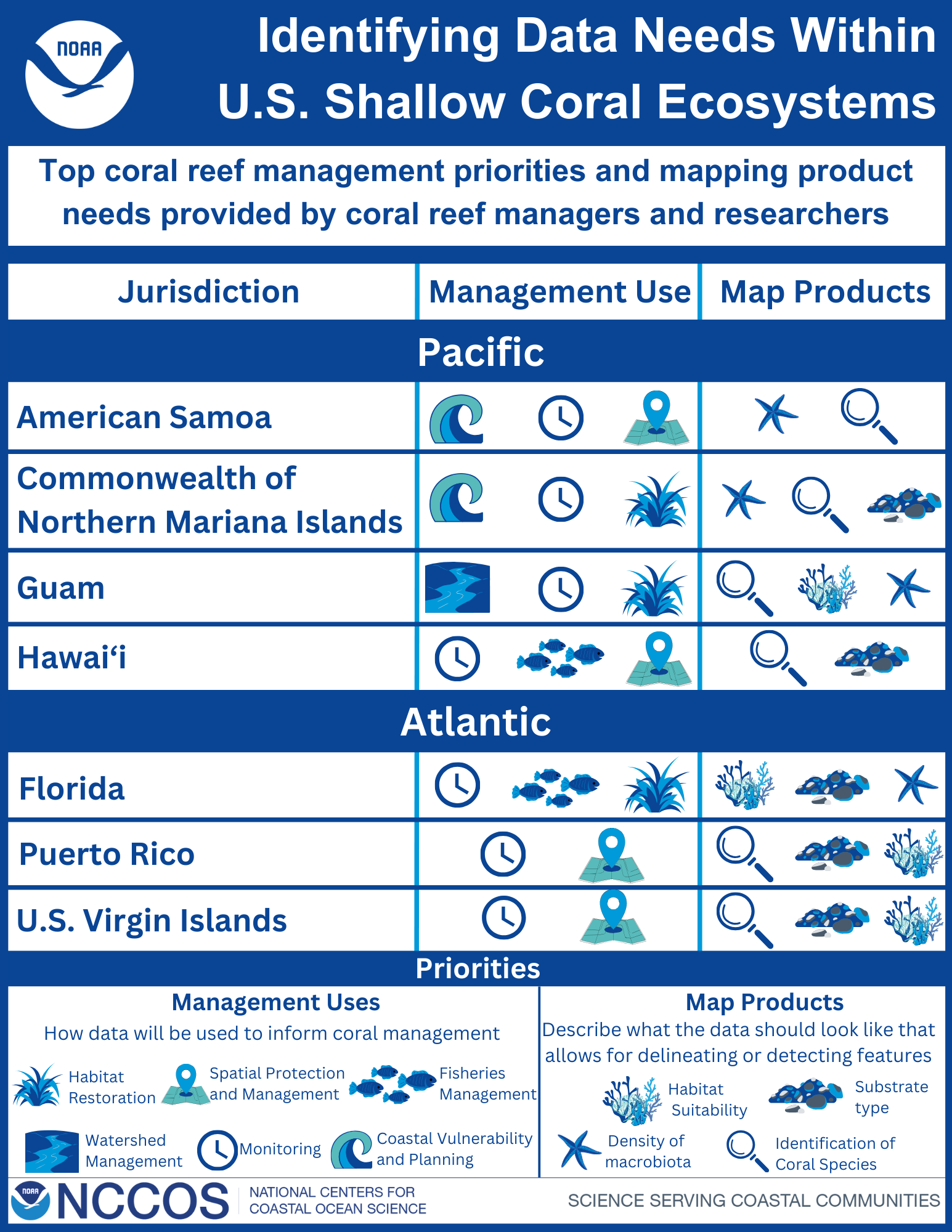
U.S. states and territories require various data types to make informed management decisions on coral reef ecosystems. However, collecting coral reef data is expensive, time consuming, and resource intensive. To overcome these challenges, managers and researchers within U.S. coral reef jurisdictions need to coordinate to understand overlapping data requirements.
 To help meet emerging coral reef management needs, NOAA’s Coral Reef Conservation Program (CRCP) funded a comprehensive, shallow-water gap analysis in 2021 within U.S. jurisdictions. CRCP partnered with NOAA’s National Centers for Coastal Ocean Science (NCCOS) to develop a systematic, quantitative, web-based approach to gather seafloor mapping priorities from local researchers and coral reef managers in all seven U.S. coral jurisdictions: American Samoa, Commonwealth of Northern Mariana Islands, Guam, Hawaii, Florida, Puerto Rico, and U.S. Virgin Islands.
Through this online application, participants placed virtual coins into a spatial grid indicating their priority areas for coral reef mapping needs. In addition, the applications allowed participants to specify why data were needed by choosing their intended management use and specific map product requirements within their selected grids. The project team compiled and analyzed these inputs to create a detailed framework for optimizing data collection to meet mapping management needs to protect, conserve, and restore the nation’s coral reefs.
From April 2021 to December 2023 the team worked with each jurisdiction to collect their data needs and priorities, which they used to identify high priority focal areas for each jurisdiction. Through this process, the team highlighted some of the best opportunities for collaboration and potential needs that would meet a variety of coral management goals. Additionally, several common management uses selected across all jurisdictions included coastal vulnerability and planning, monitoring, spatial protection and management, habitat restoration, and fisheries management. The graphic (right) outlines the top three management uses and data product needs identified by each region.
These reports will be used to inform the upcoming coral reef action plans for the covered jurisdictions under the Coral Reef Conservation Act Reauthorization (CRCA-R), which aims to protect, conserve, and restore the nation’s coral reefs by maintaining healthy ecosystem function.
Visit the project page, Agency Priorities for Mapping Shallow Coral Reef Ecosystems, to view spatial results and reports from each jurisdiction.
