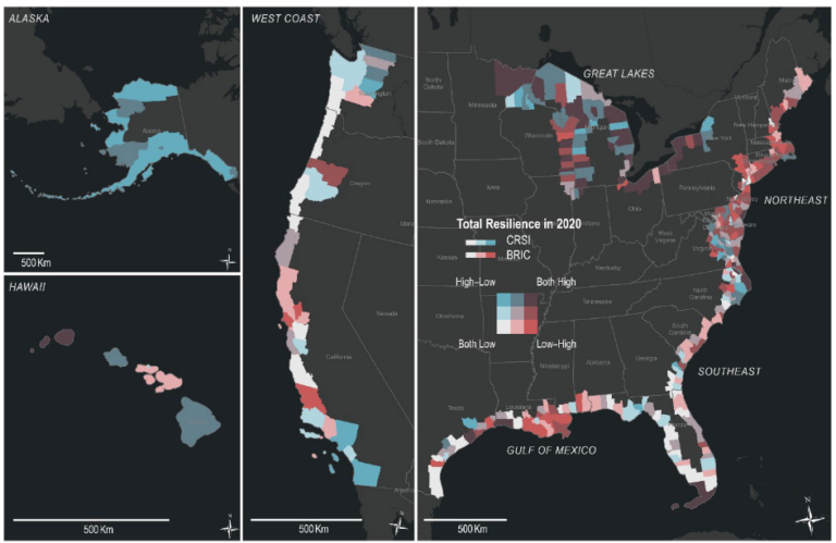
NCCOS scientists have published Understanding Resilience in Communities Across the U.S. Coastline, which compares different metrics for measuring the resilience of coastal communities across the Nation. This document builds on a portfolio of efforts in risk management, disaster preparedness, and climate readiness across NOAA by identifying metrics that can be used to better target place-based studies, restoration investments, and adaptation efforts.

Previous work by NCCOS scientists used vulnerability indices to create tools that guide coastal management decisions. In these studies, vulnerability is defined as the risk of hazard in a particular area: they do not consider the ability of a community to recover from a hazard. Coastal resilience more holistically addresses this gap; it is defined by NOAA as the “the ability of populations, ecosystems, and economies to prepare for, absorb, respond to, recover from, and successfully adapt to the impacts of natural and human-caused hazards.”
Coastal resilience can be measured in different ways depending upon the information used to inform the definition of resiliency. NCCOS researchers gathered different types of data for comparison in this study:
- Aspects of the built environment, e.g. critical infrastructure including water supply and roads
- The natural environment, e.g. wetland cover and coastal water
- Governance, e.g. flood insurance and recovery funding
- Social factors e.g. poverty rate and housing density
- Risk of exposure to hazards e.g. hurricanes and contaminants. Researchers tested how including risk into the definition shifted the locations of the most resilient communities.
These variables were mixed and matched using different mathematical equations for every coastal and Great Lakes county (not including US territories) to produce maps depicting shoreline resilience. Two main indices of resilience were chosen for the focus of this study: Baseline Resilience Indicators for Communities (BRIC) and the Cumulative Resilience Screening Index (CRSI). Researchers explored the difference between these two metrics and the maps they produced, and found pronounced differences in resilience scores, primarily due to the fact that CRSI included risk as a contributing variable to resilience.
In addition, this study explored the statistical and spatial relationships between resilience, disaster aid, and restoration funding. This identified counties with low resilience that have not historically had access to federal resources, informing how future resources can be prioritized.
