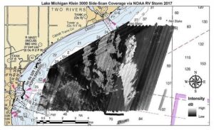
Last month a team of scientists from NOAA’s National Centers for Coastal Ocean Science (NCCOS) completed a two-week field mission aboard NOAA Research Vessel Storm to map the lakebed and explore shipwrecks in Lake Michigan. The team collaborated with the Office of National Marine Sanctuaries and the Great Lakes Environmental Research Laboratory to collect swath sonar data, acoustic backscatter, and lakebed video off Manitowoc, Wisconsin.
The mission is part of a 3-year study funded by NCCOS to gather environmental and socioeconomic data and will support management of the proposed Wisconsin–Lake Michigan National Marine Sanctuary. The team collected roughly 55 km2 of swath sonar data, greatly expanding the amount lake bottom data for Lake Michigan. NCCOS and its partners will return to collect more groundtruthing videos and map new parts of the lake in 2018

During the field mission, the mapping team and partners from the University of Wisconsin Sea Grant Institute and the University of Wisconsin–Manitowoc held an educational outreach day open to local teachers, students, and media aboard the NOAA R/V Storm in Manitowoc. The researchers demonstrated sidescan and multibeam echosounders, a drop-camera, and a remotely operated vehicle to showcase the scientific tools involved in lakebed mapping.
For more information, contact Charles.Menza@noaa.gov.
