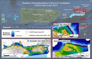
To provide new high resolution data for the nearshore waters of St. Thomas, St. John, andSt Croix, USVI, NCCOS scientists partneredwith NOAA’s Office of Coastal Survey, Fugro LADS Corporation, and the US Virgin Islands TerritorialGovernment. The new data filled what were previously significant data gaps in coastal waters (0-30m water depth).
NOAA’s Office of Coast Survey contracted for the collection of these data primarilymeet navigational charting updates and NOAA’s commitment to integrated ocean and coastal mapping(“Map once… use many times”). The data will assist Territorial resource managers and NOAA scientistsbetter understand the extent and condition of coral reef ecosystems and associated marine life.
Thelocations surveyed are at tremendous risk of human and natural impacts.

