Wave Exposure Model (WEMo)
The Issue
 Hydrodynamic factors profoundly impact the environment of coastal areas. Wind waves, particularly waves associated with storms, are unpredictable and can pose dangerous situations under which to collect scientifically empirical, comparative information. Unfortunately, there are few simple–to–use, inexpensive tools that can provide a quantitative value of wave energy for locations not in the open ocean. Such a tool is needed by resource managers who need to estimate wave energy in coastal regions or in inland waters to gauge susceptibility of developed areas. This tool is also needed by scientists who desire a quantitative measure of wave effects to relate to ecosystem function.
Approach
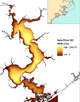
CCFHR scientists have developed an easy-to-use numerical wave exposure model (WEMo) that uses linear wave theory to calculate actual wave height and derived wave energy while taking into consideration wind generation and local water depth characteristics such as shoaling and dissipation from breaking waves. WEMo also provides predictions of seafloor sediment movement.
Features
The model works in a simple Geographic Information System (GIS) format in association with ArcGIS:
- Forecasts (and hindcasts) quantitative and geographically accurate wave energy and seafloor sediment movement for enclosed or semi-enclosed water bodies (e.g., estuaries and lakes)
- Foundation for studying or modeling restoration success, seafloor and shoreline erosion, and limits to habitat tolerances.
- Integrates easily with standard data formats for association with dependent factors such as shoreline erosion, landscape patterns and faunal associations.
- Guides sample stratification by wave energy regime.
- Adaptable for use by non-specialists in hydrodynamics; designed for those with basic knowledge of Geographic Information Systems (advanced college class, introductory graduate level classes)
- Tunable to either chronic or extreme wind events as well as in synchrony with storm surge.
Applications
WEMo is being applied to a number of geographic areas including Tampa Bay, FL, Chesapeake Bay, MD & VA, Core Sound and New River, NC, and Prince William Sound, AK.
Examples of potential applications include:
- seagrass exclusion areas (i.e., areas where wave energy is too high for persistent seagrass habitat);
- the potential for restoration of seagrass;
- submersed and shoreline habitat landscape pattern;
- shoreline susceptibility to hurricanes and other extreme wind events;
- effect of shoreline structures on habitat.
Downloads

Wave Exposure Model (WEMo)
Version 4.0 (updated March 2010). Compatible with ArcGIS 9.3.

Wave Exposure Model (WEMo) Manual
Version 4.0 (updated March 2010).
Previous Versions
Wave Exposure Model (WEMo), version 3.1
Updated September 2008
Compatible with ArcGIS 9.2
WEMo was modified in this version to calculate wave period and maximum wave direction along with automatic wind data processing.
Download WEMo 3.1
Download Manual for Version 3.1
Wave Exposure Model (WEMo), version 3.0
Updated October 2007
Compatible with ArcGIS 9.1
WEMo was modified in this version to calculate wave height and derived Representative Wave Energy along with the relative index (REI) calculated in older WEMo versions.
Download WEMo 3.0
Download Manual for Version 3.0
Citation for this work: Tech Memo: NOS NCCOS 65, WEMo (Wave Exposure Model): Formulation, Procedures and Validation
This report describes the working of National Centers for Coastal Ocean Service’s WEMo, capable of predicting the exposure of a site in estuarine and closed water to local wind–generated waves and validation of the model using wave sensors collected data.
Download
