More Information About HAB Products
The Harmful Algal Bloom Forecasting Branch (HAB FB) of the National Centers for Coastal Ocean Science (NCCOS) outputs a number of remote sensing products to aid resource managers and public health officials in responding to fresh and saltwater HABs. While phytoplankton species cannot be distinguished by satellite, we can detect high biomass blooms and separate bloom types by measuring proxies that estimate Chl-a, the main component of the blooms, or look at the optical characteristics of the bloom and surrounding waters in which they occur. To do this, we have applied several algorithms to the Ocean Land Color Imager (OLCI) onboard the Sentinel 3 satellite suite and the Multispectral Instrument (MSI) which is aboard the Sentinel 2 satellite suite. Both satellites were launched by the European Space Agency (ESA); and Sentinel-3 is maintained by EUMETSAT, while Sentinel-2 is maintained by ESA.
- Details regarding these satellite derived products and others provided by the HAB FB at NCCOS can be found in the Technical Report found here.
- For more information on our phytoplankton bloom products or for access to historical image products, please contact hab@noaa.gov.
- Please visit the Harmful Algal Bloom Monitoring System page to see what bloom monitoring imagery products are currently available.

Frequently Asked Questions
The primary driver for that type of day to day variability is likely due to mixing of the bloom in the water column by winds. The sensor is only picking up signal from the surface water layer so non-detection does not mean the bloom has dissipated. Where appropriate and available, our PNG maps include information on wind speed and direction at the time of the satellite overpass. When the winds are less than about 5 mph, blooms are typically at the surface, and they get mixed (and surface concentration decreases) as the wind increases. To get a true understanding of the size, location, and development of the bloom, it is important to look at images over a number of days.
This could be due to a number of factors. Blooms can be patchy so samples only represent a specific point in the water body, whereas each pixel in the image represents an average within a 300 m x 300 m area (1000 ft x 1000 ft), the size of a football stadium. As the signal is only from the surface layer, it may not match observations taken below the surface. The products from the satellite imagery analysis are also unlikely to pick up blooms within 300 m of the shore. Low concentration blooms identified in the image products may not be visible to the human eye.
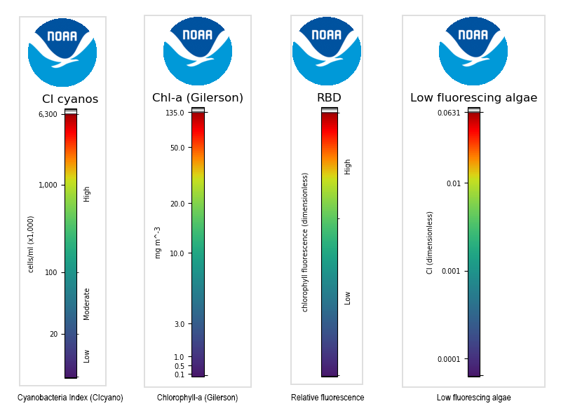
Images are color scaled to highlight important features (e.g., low, med, high bloom levels). The following series of scaled color bars are provided to aid interpretation when viewing each product.

The important point regarding gray pixels is that they are invalid and therefore contain no useful data. Identifying the actual reason for flagging as invalid (i.e. cloud, mixed land/water, stray light) is more for our benefit to assess algorithm performance.
The products are continually being evaluated and improved. They have been made available to help inform resource managers and public health officials responding to Harmful Algal Blooms.
- True Color : a Red, Green, Blue (RGB) composite image.
- Chlorophyll-a (RE10) : chlorophyll a concentration determined by a near-Infrared to red ratio as described by Gilerson et al. (2010).
- Cyanobacteria Index : the relative abundance of cyanobacteria biomass as determined by the cyanobacteria index algorithm developed by Wynne et al. (2008).
- Relative Fluorescence (RBD): the relative chlorophyll fluorescence representative of chlorophyll concentration for high biomass blooms, determined by the Red-Band Difference developed by Amin et al. (2009).
- Chlorophyll-a Anomaly : highlights increased chlorophyll concentrations (new blooms) compared to the mean chlorophyll calculated from the past two months.
