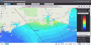
As Tropical Storm Gordon headed for the Mississippi and Alabama coastlines, a version of the NCCOS-sponsored Northern Gulf of Mexico ADCIRC+SWAN model ran in real-time providing storm surge and wave guidance for disaster response agencies.
Model results are displayed on the Coastal Emergency Risks Assessment (CERA) website at the Louisiana State University Center for Computation & Technology (viewing model runs requires a login).
The coupled Northern Gulf of Mexico ADCIRC+SWAN model (ADvanced CIRCulation and Simulating WAves Nearshore) is a product of the NCCOS EESLR project in the Northern Gulf of Mexico. Optimization and transition of the model for operational forecasts was funded, in part, by the Department of Homeland Security’s Coastal Resilience Center of Excellence. .
For more information, contact Dave.Kidwell@noaa.gov,
