PLEASE NOTE: THIS IS A DEVELOPMENT SITE, AND THE CONTENT DOES NOT REFLECT THE MOST CURRENT INFORMATION.

Chesapeake Bay Harmful Algal Bloom Forecast System

NOAA is providing forecasts in Chesapeake Bay for harmful algal blooms (HABs) of the dinoflagellate Margalefidinium polykrikoides, often known as rust tide, which typically blooms from late July to October. Blooms have been observed annually in the York River since 2007, and in more recent years in the lower Bay’s mainstem and in the James, Elizabeth and Lafayette Rivers. These blooms are a concern due to their impact on water quality and toxicity to finfish and shellfish. A demonstration forecast is currently being run for the York River, VA and will be expanded to other regions of the Bay pending validation efforts. A combination of satellite imagery (showing bloom location and extent) and a coupled bio-physical model provides information on the current status of the bloom and forecasted position at both surface and at depth over the next 6 days. See individual products and our FAQs for more information.

Forecast Products

Welcome to the new home of the Chesapeake Bay Harmful Algal Bloom Forecast System. No bloom of M. polykrikoides has been observed at this time. ##--NCCOS HAB Forecasting Team
The Chesapeake Bay Harmful Algal Bloom Forecast is operated by the National Centers for Coastal Ocean Science.
Contact hab@noaa.gov for technical questions. Last Updated: 2024-08-29 10 AM EST

Map of Chesapeake Bay with one tributary showing presence of M. polykriokoides

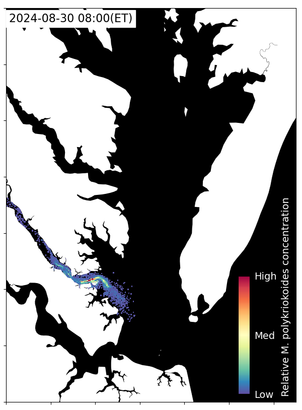
Forecasted Bloom Position

(from modelling)

Forecasted extent and position of the bloom for a minimum of 96 hours, based on a combination of a hydrodynamic modeled currents and satellite imagery for initial bloom location.

Map of Chesapeake Bay with colorful specks throughout the bay and in some of the tributaries.

Observed Bloom Position

(from most recent satellite image)

Current satellite imagery from the Ocean Land Color Imager (OLCI) and true color imagery showing bloom location and extent.

More Information:

Background Information on M. polykrikoides:

Field Observations:

Hydrodynamic Model:

  • SCHISM based model for the Chesapeake Bay region (2-3 km on the ocean shelf) with finer resolution grid in the tributaries (100-300 m; Rappahanock, York, and James rivers)
  • Salinity, temperature, and subtidal horizontal velocity at the ocean boundary is forced by  global HYCOM
    • A nudging zone of ~30 km near the open boundary is used to relax simulated salinity and temperature toward the HYCOM product 
  • Water level at the open boundary is interpolated from two tidal gauges at Lewes, DE and Beaufort, NC following Ye et al. (2018)
  • Daily river discharge and temperature for major tributaries are from the United States Geological Survey (USGS)
  • Atmospheric forces are obtained from NOAA’s Global Forecast System (GFS)
  • Initial salinity and temperature is based on Chesapeake Bay Program surveys (Chesapeake Bay and tributaries) and HYCOM (shelf)

Key References:

Clayton S, Chrabot JB, Echevarria M, Gibala-Smith L, Mogatas K, Bernhardt P and Mulholland MR (2024) Diel vertical migration rates of the dinoflagellate species Margalefidinium polykrikoides in a lower Chesapeake Bay tributary. Front. Microbiol. 15:1378552. doi: 10.3389/fmicb.2024.1378552

Hofmann EE, Klinck JM, Filippino KC, Egerton T, Davis LB, Echevarría M, and Mullholland MR (2021) Understanding controls on Margalefidinium polykrikoides blooms in the lower Chesapeake Bay. Harmful Algae 107:102064. doi: 10.1016/j.hal.2021.102064

Qin Q, Shen J, Reece KS, and Mulholland MR (2021) Developing a 3D mechanistic model for examining factors contributing to harmful blooms of Margalefidinium polykrikoides in a temperate estuary. Harmful Algae 105:102055. doi: 10.1016/j.hal.2021.102055

Wolny JL, Tomlinson MC, Schollaert Uz S, Egerton TA, McKay JR, Meredith A, Reece KS, Scott GP and Stumpf RP (2020) Current and Future Remote Sensing of Harmful Algal Blooms in the Chesapeake Bay to Support the Shellfish Industry. Front. Mar. Sci. 7:337. doi: 10.3389/fmars.2020.00337

Xiong J, Shen J, Qin Q, Tomlinson MC, Zhang YJ, Cai X, Ye F, Cui L, and Mulholland MR. (2023) Biophysical interactions control the progression of harmful algal blooms in Chesapeake Bay: A novel Lagrangian particle tracking model with mixotrophic growth and vertical migration. Limnology Oceanography Lett. 8:498–508. doi: 10.1002/lol2.10308

Ye F, Zhang YJ, Wang HV, Friedrichs MAM, Irby ID, Alteljevich E, Valle-Levinson A, Wang Z, Huang H, Shen J, and Du J. (2018) A 3D unstructured-grid model for Chesapeake Bay: Importance of bathymetry. Ocean Model. 127:16–39. doi: 10.1016/j.ocemod.2018.05.002

Yu X, Tomlinson MC, Shen J, Li Y, Hounshell AG, Scott GP and Reece KS (2025) Using a coupled satellite image-numerical model framework to simulate Margalefidinum polykrikoides in the York River estuary. Front. Mar. Sci. 12:1561340. doi: 10.3389/fmars.2025.1561340

Zhang YJ, Ye F, Stanev EV, and Grashorn S. (2016) Seamless cross-scale modeling with SCHISM. Ocean Model. 102, 64–81. doi: 10.1016/j.ocemod.2016.05.002